Documenting and monitoring stream flow is an integral part of developing water budgets, conducting loading calculations, evaluating the relationship between groundwater and surface water, and is critical in evaluating impacts from urban runoff.
. There are a number of methods to document stream flow (Q) which is in units of volume/time such as gallons/minute, liters/second, and cubic feet/second. The most typical method for a field evaluation of Q is to develop a cross-section of a stream segment or channel. The cross-section, perpendicular to the flow of the water, can be used to define a cross-sectional area (A) which, in the simplest rectangular case, would be depth x width. Flow, then, would be Q = Av where v = the velocity of the water. Note that area x velocity results in units of volume/time.
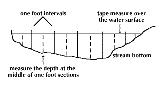
Unfortunately, the cross-section of a real stream is rarely rectangular so A ≠ width x depth. In such a case, the cross-section can be subdivided into smaller areas which can be approximated as rectangles. If you multiply each small area by the water velocity you will get the flow for each smaller area. Add up those individual flows to get a reasonable flow for the entire cross-sectional area. There is, however, yet another problem. The water velocity in each of the smaller areas is not necessarily the same. For example, water velocity near the sides and bottom of the stream will be lower than water velocity in the middle of the stream. If you want a more accurate calculation of flow, you would have to take water velocity measurements in different parts of the stream cross-section.
Step 1 | Selecting the Channel Location
The area to be monitored should be a stable stream channel, one which is not significantly altered by erosion/sedimentation or meandering. The portion of the stream to monitor should not be a braided section (there is so much sand in the stream channel that the water flow has numerous subchannels which divide and rejoin) of the stream or a meandering area. If possible, the section to be monitored should have flow that is parallel to the stream channel orientation and not within a pool area or other area altered by structures that may create backwater areas or reverse the flow (eddies) of the water. The site should be accessible. In some cases, you may need to slightly modify a section of the stream to obtain the optimal conditions to accurately document stream flow. The stream channel should be clear of debris.
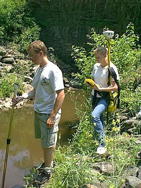
Step 2 | Developing a Cross-Section of the Site and Establishing a Reference or Staff Gauge
These methods utilize a velocity-area approach to measuring stream flow (or volume of water passing a set point in a given period of time). That is, to determine flow, the monitors combine information about stream cross-sectional area with information about the velocity of the water at their site.
If possible, the section of the stream used for this measurement should be relatively stable, i.e., not actively downcutting or meandering. In addition, it would be advisable to select a stream where the flow is nearly parallel to the stream channel and not immediately after or before a meander or rapid. When developing the cross-section, it may be necessary to remove or relocate some of the stream channel bottom material to create a more uniform bottom. It is also advisable to extend the cross-section to a point that is above the flood level for the stream.
Step 3 | Measuring Interval and Depth
Monitors measure the area of the stream at their site by measuring the width across the stream and the depth at several locations across the measured width. For a small stream, the width interval between measurements is typically 6 inches. For larger streams, intervals of one foot can be used.
The stream is divided into rectangular grids and the water velocity at 60% of the stream depth is measured. Velocity can be measured with a number of different velocity measuring devices.
By documenting velocity and cross-sectional area, we can calculate volume and flow. When you know the volume of the water under different conditions and the water quality, you can calculate pollutant loadings.
Pounds per day = Flow (MGD- million gallons per day) * (Concentration, mg/L) * 8.34 lbs/gallon
If you are looking to create estimated pollutant loadings, you may want to review the "Simple Method.” "The Simple Method estimates stormwater runoff pollutant loads for urban areas. This technique requires a modest amount of information, including the sub-watershed drainage area and impervious cover area, stormwater runoff-pollutant concentrations, and annual precipitation. With the Simple Method, the investigator can either break up land use into specific areas, such as residential, commercial, industrial, and roadway and calculate annual pollutant loads for each type of land use, or utilize more generalized pollutant values for land uses such as new suburban areas, older urban areas, central business districts, and highways." (Source)